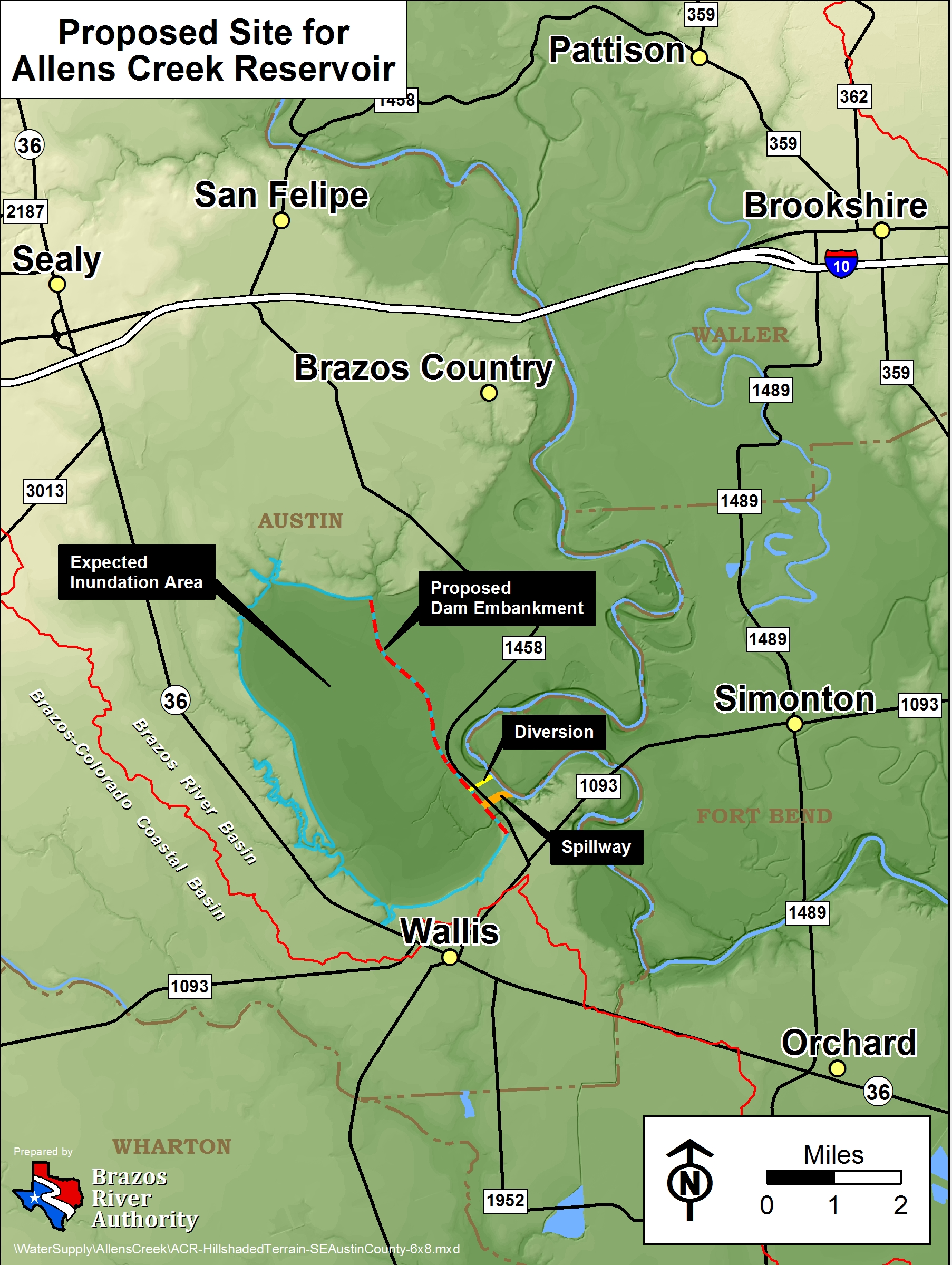
Drive State Highway 36 south from Sealy toward Wallis and the countryside still looks unmistakably rural Texas. Farm fields stretch toward the horizon. Cattle graze. Allens Creek winds through low country toward the Brazos River. Nothing from the highway announces that thousands of acres here have been assembled for a lake that could one day cover roughly 7,000 acres.
Yet that is the plan. The Brazos River Authority owns approximately 9,559 acres between Highway 36 and the Brazos River, north of Wallis and south of Sealy. Much of the property remains under interim farming and grazing leases while the reservoir works its way through years of engineering and permitting. [1]
If ultimately built, Allens Creek Reservoir would not simply add another blue shape to a Texas highway map. It would become a major storage component in the Lower Brazos water system at a time when Fort Bend County, Brazoria County and the greater Houston region continue to add people, businesses and industrial demand.
Not a Dam Across the Brazos
The first thing to understand about Allens Creek Reservoir is what it is not. No one plans to build a giant dam across the Brazos River at Wallis.
Allens Creek is planned as an off-channel, pumped-storage reservoir. An earthen embankment would impound Allens Creek and the surrounding reservoir basin beside the Brazos. When river flows are sufficiently high and water is legally available, pumps would move water from the Brazos into the reservoir. That water could remain in storage until drought, population demand or system operations make it valuable later. [1] [4]
In simple terms
Think of the reservoir as a very large savings account for water. The Brazos River delivers water unevenly. At times there is more water passing downstream than can be put to beneficial use. During drought, the opposite can be true. Allens Creek is intended to capture some legally available water during wetter periods and store it for the future.
adequate flow
moves water
stores water
The Project by the Numbers
Figures are based on current BRA materials and the adopted 2026 Region H Regional Water Plan and remain subject to refinement during design and permitting.
History A Reservoir Born From a Power Plant That Was Never Built
The origins of Allens Creek Reservoir reach back to 1974, when Houston Lighting & Power received a water-right permit for a reservoir that would supply cooling water to a proposed nuclear power plant. The plant was never built. The nuclear project disappeared, and the original reservoir permit eventually expired. [1]
The location, however, did not stop making sense as a place to store water. Texas lawmakers later created a path for the project to return as a water supply reservoir. In 2000 the Brazos River Authority and City of Houston acquired the property, with financing participation by the Texas Water Development Board.
At the time, Houston was expected to need most of the future reservoir's supply. The arrangement generally contemplated Houston taking the larger share and BRA the smaller. But water planning changed. Houston developed other supply options while demand continued to grow elsewhere in the Brazos Basin, particularly in Fort Bend and Brazoria counties. [1]
In May 2022, BRA acquired the remaining interests and became the sole owner and developer of the reservoir project. That change was more than paperwork. A project that had spent years in something close to suspended animation finally had one owner with a direct reason to move it forward.
A water-right permit is issued for a reservoir intended to supply cooling water for a proposed nuclear power plant.
The nuclear project is abandoned. The original reservoir permit eventually expires.
BRA and the City of Houston acquire the Allens Creek property. The reservoir re-emerges as a future regional water-supply project.
BRA purchases the remaining project interests and becomes the sole owner and developer.
TCEQ amends Water Use Permit No. 2925B, moving the state deadline to commence construction to September 1, 2035.
Environmental, geotechnical, cultural-resource and other field investigations advance as BRA prepares the project for federal permitting.
BRA authorizes a professional-services engineering contract with GFT Infrastructure and an initial work plan of up to $18,811,652 through August 2027. [3]
The adopted 2026 Region H Water Plan identifies 2040 as the implementation decade for the reservoir. This is a planning assumption, not a guaranteed opening date. [4]
Why Build It Now?
Water projects are rarely built for the population that exists on the day construction begins. They are built for the population expected decades later.
The Lower Brazos Basin is no longer the mostly rural region it was when Allens Creek was first contemplated. Fort Bend County has become one of the largest and fastest-growing suburban counties in Texas. Industrial and municipal demand continues downstream toward Brazoria County and the Gulf Coast. At the same time, parts of the region face pressure to reduce reliance on groundwater because excessive groundwater withdrawal contributes to land subsidence. [2]
A new reservoir in the lower basin gives BRA something especially useful: storage close to growing demand. Instead of relying only on water stored hundreds of miles upstream, the system would be able to capture water from the lower Brazos during favorable river conditions and hold it near the customers that may eventually need it.
“The real value of Allens Creek is not simply that it creates a lake. It creates time, allowing water available during wet periods to be saved for the dry ones.”
How Much Will It Cost?
There is not yet a final construction price, and anyone presenting one as settled is getting ahead of the engineering.
BRA currently describes the total project cost as roughly $700 million, with the estimate expected to become more precise as federal permitting and design advance. Meanwhile, the technical analysis in the adopted 2026 Region H Water Plan lists a capital cost of approximately $493.9 million in September 2023 dollars. Those numbers are not necessarily contradictory. They reflect different planning assumptions, dates and levels of project development. [1] [4]
The important point is simpler: Allens Creek is a project measured in hundreds of millions of dollars, and its eventual cost will depend on final engineering, mitigation requirements, materials, construction markets, financing and the years that pass before major construction begins.
The Permit That Matters Most
BRA already owns the land and holds the state water rights needed for the project. The great remaining regulatory hurdle is the federal Clean Water Act Section 404 process administered through the U.S. Army Corps of Engineers.
That process is why construction cannot simply begin because a conceptual dam line exists on a map. Engineers and environmental specialists must evaluate wetlands, streams, wildlife, cultural resources, archeological sites, cemeteries, alternatives, drainage, flood behavior and other potential impacts. Where adverse impacts cannot be avoided, mitigation may be required. [1]
BRA estimates the permitting and design phase could require approximately five to ten years, followed by another four to seven years of construction. That is why 2040 is a more useful planning horizon than any promise of an exact opening day.
The Question Locals Ask First What About Flooding?
For people who live along this part of the Brazos, nearly every discussion about a new 7,000-acre reservoir eventually reaches the same subject.
Flooding here is not theoretical.
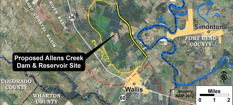
Simonton, Wallis and the surrounding Brazos bottomlands occupy a landscape shaped by the river. The Brazos has left its banks repeatedly, spreading across roads, fields and communities that may appear a considerable distance from the ordinary river channel.
The City of Simonton's own comprehensive planning documents describe major Brazos River flood events in 2015, 2016 and 2017. In May 2016, roughly 250 homes in Simonton were affected and mandatory evacuations were required in some areas. During Hurricane Harvey in August 2017, the city's plan reports that approximately 80 percent of Simonton flooded. [5]
Those memories matter because the proposed reservoir property sits immediately beside the Brazos and because the dam embankment would become a major new man-made feature in an already complicated floodplain environment.
Allens Creek Reservoir is not being designed as a flood-control reservoir.
BRA states this explicitly. Unlike a reservoir built primarily for flood control, Allens Creek's principal purpose is water supply. Its storage is intended to hold usable water rather than maintain a large empty flood pool waiting for the next storm. [1]
Could the reservoir make flooding worse?
That is one of the questions the permitting and engineering process is required to answer.
BRA says studies must evaluate the project's potential effect on flooding and that if the reservoir would negatively affect flooding, those impacts must be mitigated or avoided. That could mean engineering changes, drainage modifications or changes in project configuration depending on what detailed hydraulic modeling ultimately shows. [1]
The concern is understandable. A miles-long embankment placed in a low-lying river environment inevitably raises questions about where floodwater would go, whether existing drainage paths would change, how water moves around the structure during extreme events and what happens at the spillway and outlet works. Those are engineering questions, not questions that can responsibly be answered by looking at a project map alone.
Could the reservoir actually help?
Possibly, in limited circumstances, but that should not be confused with calling Allens Creek a flood-control project.
Because the reservoir will pump water from the Brazos when river flows are adequate and because its design necessarily interacts with local drainage, future engineering could conceivably produce localized drainage benefits or allow some water to be captured at favorable times. BRA's own FAQ specifically acknowledges questions about whether flooding and drainage problems around Sealy and Wallis could be addressed in connection with the project.
BRA's present answer is appropriately cautious: detailed flood studies around the proposed site are part of the engineering and permitting phase. Until those studies are completed and publicly available, claims that the reservoir will either solve regional flooding or worsen it should be treated as unproven. [1]
What happens when the Brazos itself is in flood?
The reservoir's pumps do not mean BRA will indiscriminately pump floodwater into the lake whenever the river rises. Diversions remain governed by the project's water rights, environmental requirements, operating rules, reservoir capacity and the physical limitations of the intake and pumping system.
The reservoir will also receive some natural inflow from the Allens Creek watershed. Its spillway and outlet system therefore must be engineered to safely manage water entering the reservoir as well as releases from it.
For nearby residents, the most important future documents may not be glossy renderings of the lake at all. They will be the hydraulic models, flood-impact studies, drainage plans and final engineering drawings produced during permitting. Those documents will tell the community far more about local flood consequences than conceptual maps can tell us today.
Bottom line: flooding is a legitimate local concern, the reservoir is not a flood-control reservoir, and the final answer about its effect on surrounding flood behavior will depend on engineering studies that are still part of the ongoing permitting process.
Life on the Future Lake Will People Be Able to Boat and Fish Here?
Formally, BRA's current answer is that recreation may be allowed, with a final determination expected after the federal Section 404 process. That cautious language is important because the project has not yet completed permitting or final design. [1]
The broader record, however, makes the likely direction fairly clear. BRA has repeatedly discussed recreational opportunities at Allens Creek. Earlier project announcements stated that recreation would be allowed, although potentially on a limited basis because lake levels could fluctuate. BRA has also publicly said it is committed to making recreational opportunities available and has discussed possibilities including boating, fishing and public access. [7]
The likely question is not simply “recreation or no recreation?”
The more useful questions are likely to be: How much public access? Where will the boat ramps and parks be? Will camping be offered? How much shoreline will be accessible? And how will fluctuating water levels affect boating and fishing during drought?
BRA's existing water-supply reservoirs, Possum Kingdom Lake, Lake Granbury and Lake Limestone, all support public recreation. Parks, boat ramps, fishing, boating and other uses coexist with their primary water-supply purpose. [8]
Allens Creek would likely differ from the image many people have of a constant-level suburban lake. Water stored here is meant to be used. During extended drought or heavy water demand, the shoreline could move substantially as reservoir levels fall. BRA specifically cautions that water levels may fluctuate significantly.
That does not make recreation unimportant. A new lake of this size in Austin County would almost inevitably attract anglers, boaters, wildlife watchers and visitors. It could also affect nearby land use and economic activity in ways that are impossible to fully predict years before the first boat ramp is designed.
What Happens Next?
The phrase “proposed reservoir” can make a project sound hypothetical. Allens Creek is further along than that phrase sometimes suggests.
BRA already owns the property. It already holds the state water right. Millions of dollars are now being spent on engineering, environmental work and federal permitting. The 2026 BRA engineering authorization represents active project development rather than merely a line item in a distant water plan. [3]
Yet there is also a long distance between an active project and a finished lake. Federal authorization must be secured. Flood and environmental impacts must be studied. Final engineering must be completed. Financing must keep pace with the project. Construction itself could take years, followed by the process of filling a reservoir whose water can only be captured when legal and hydrologic conditions permit.
In other words, Allens Creek is neither a fantasy nor a lake that will appear next summer.
It is a major Texas infrastructure project slowly moving from paper, permits and soil borings toward something much more visible. For the people of Wallis, Simonton, Sealy and the communities of the Lower Brazos, that makes the next several years worth watching.